Marius Riba
Blog / Leadership & Transformation
The tactical urban planning of the Superblocks of Eixample district (Barcelona)
Categories
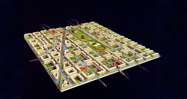
THE GRIDED URBAN MASTERPLAN OF ILDEFONS CERDÀ – THE BARCELONA ENGINEER AND URBAN PLANNER WHO DESIGNED AND REFORMED THE CITY OF BARCELONA WITH THE CERDÀ'S PLAN BACK IN 1860 – IS ONCE AGAIN UNDER TEST FOR CONVERTING IT INTO A MORE SUSTAINABLE CITY. WHILE A FEW YEARS AGO WE SAW TESTINGS WITH THE SUPERBLOCKS - LOCALLY KNOWN AS “SUPERILLES”- PROJECT IN THE POBLENOU NEIGHBOURHOOD, NOW, THE PROPOSAL IS BEING TAKEN TO A LARGER SCALE JUST IN THE CORE OF THE DISTRICTS THAT CERDÀ HIMSELF CREATED, THE EIXAMPLE, ORIGINALLY KNOWN AS THE BARCELONA'S ENSANCHE.
In this article we will delve into the roots of this urban space, from its conception to the problems that the city has experienced, and continues to experience today. Thus, we will end by analysing in detail the "Superilla de l'Eixample", or superblocks, a Smart project that aims to reduce pollution and improve mobility in one of the cities with the worst air quality in Spain. Barcelona has to prove that it is a Smart City, and it is working on it.
The masterplan: a grid structure, open and egalitarian
Determining that the urban morphology of Barcelona's Eixample is based on the criteria of the grid town planning is instantaneous if you look at it from the sky. To understand at what point Barcelona became similar to a chessboard we need to go back to the 19th century (1841), when Barcelona City Council opened a concourse with the aim of promoting the development of the city, where several projects intended to expand the existing walled city. Thereby, the “Pla Cerdà”, with its prosperous and optimistic urban language, would go ahead, giving the city a geometric character with a strong focus on hygienic aspects and mobility.
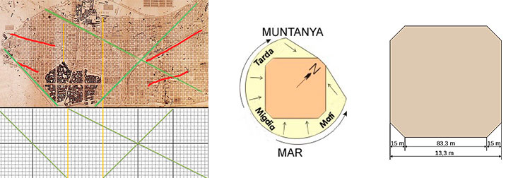
Original planning axes of Eixample district / Orientation of the blocks of Eixample / Design of the blocks´ quadrilaterals of Eixample This new configuration, which took almost a century to materialise, would take maximum advantage of the direction of the winds to facilitate oxygenation and clean air. It also proposed a continuous grid of 113.3-metre blocks, from the Besós to Montjuic (opposite poles of the city) with 45º chamfers to allow better visibility. Intelligent urban planning.
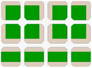
Design and grouping of blocks However, the search for homogeneity pursued by the plan was not only about equality between social classes, but also about the comfort of traffic and people. This is why the concept of mobility is such an important aspect of the "Superilla de l'Eixample" project. To understand its peculiar geometry a little better, we can see how Cerdà conceived two basic shapes in the spaces of each block to locate the buildings. One had two parallel blocks located on opposite sides, leaving a large rectangular space inside for garden areas, while the other had two blocks joined in an "L" shape, leaving a large square space in the rest of the block also for gardens.
Historical change in mobility: from the tram to the bicycle through the automobile boom
In terms of traffic and mobility, it is also worth looking back to see the Eixample Superblocks project in perspective. It was not until 1950 that the city's extensive tram network began to experience a series of urban planning problems directly related to population growth. Due to the growing demographic waves towards the metropolitan area, the original tram network was progressively replaced by the presence of the private car, the new buses and, in general, the automobile boom. In 1971, the old tram network disappeared for good. Today, the only legacy that allows us to go back to that time is the Tramvia Blau, which starts at Plaza Kennedy.

Tactical urban planning. Street in the Eixample district in Barcelona. The Eixample, as a central district which thousands of vehicles have historically circulated and continue to circulate, and through which some of the city's main arteries cross, is certainly a scenario in which traffic must be pacified. With the historical context on the table, and without ignoring the close relationship between traffic and pollution, the proposal of Superblocks of the Eixample district is born with the desire to reverse not only the problem of excessive space for road traffic, but also the endemic ills that this brings: ultimately, pollution and damage to public health. As for how the city deals with NO2 and PM10 levels, we will leave that for another chapter.
Superilla de l'Eixample: the prioritization of the road network
The Superblocks are made up of approximately 4 to 5 blocks, and within them, motorized traffic is reduced to a minimum, as well as parking areas for surface vehicles, providing maximum priority to pedestrians in the public space. In this way, the Superblocks become the link between urban planning and mobility planning, always with the aim of limiting the presence of private vehicles in public space.

Map of the "Superilla Barcelona". Cerdà's transforming project
Characteristics:
Undoubtedly, the project results in an improvement of urban quality, as it reduces the environmental impact and increases the quality of life of neighbours and visitors. In addition, it also increases social cohesion and economic activity. To appreciate this, we only have to analyse the area of Sant Antoni and see how all these factors act as real urban catalysts. Among the main features of the project, we would distinguish the following:
Universal accessibility: it proposes single-section streets.
Safety: Due to the required speed limit of 10 km/h.
Habitability: These measures increase its potential as an area. In practical terms, it is more comfortable.
To turn this great project by Cerdà into the new great green axis of Barcelona, it is necessary to continue to opt for tactical urban planning, a simple formula for urban transformation that allows the use of a space to be changed with temporary and economic elements. This is a concept that is not new. We can observe cities such as Paris, New York, Vienna or Milan ("Strade Aparte" is certainly another project that deserves an article) to notice that this is a clear net among today's Smart Cities.
TO SUM UP: TACTICAL URBANISM ESTABLISHES LONG-TERM STRATEGIES AND THEREFORE REQUIRES TACTICAL INTERVENTIONS TO ADAPT THE SHORTCOMINGS OF A CONVENTIONAL MODEL, ESTABLISHING TOOLS AND MEASURES THAT CAN BE APPLIED QUICKLY, REDUCE COSTS AND, ABOVE ALL, PROPOSE TEMPORARY SOLUTIONS TO THE PROBLEMS DETECTED. IN THIS CASE, IT PROPOSES AN ALTERNATIVE MODEL TO ACHIEVE URBAN REGENERATION THAT WORKS MAINLY ON A SMALL SCALE. MOREOVER, AS WE HAVE SEEN AND ARE SEEING, A TACTICAL PROJECT CAN LEAD TO POSITIVE CHANGES IN AN ENTIRE NEIGHBOURHOOD.
Sources: 1. Guillem¡s documentary thread: https://twitter.com/Foskopolitano/status/1329039698975715329 2. Wikipedia Plan Cerdà: https://es.wikipedia.org/wiki/Plan_Cerd%C3%A1 3. Ajuntament de Barcelona: https://ajuntament.barcelona.cat/superilles/es/


